Area, Zone, Region
Some geographical concepts in power systems
Balancing Authority Area
The collection of generation, transmission, and loads within the metered boundaries of the Balancing Authority. The Balancing Authority maintains load-resource balance within this area.
Reliability Coordinator Area
The collection of generation, transmission, and loads within the boundaries of the Reliability Coordinator. Its boundary coincides with one or more Balancing Authority Areas.
Control Area
An electric power system or combination of electric power systems to which a common automatic control scheme is applied in order to:
- Match, at all times, the power output of the generators within the electric power system(s) and capacity and energy purchased from entities outside the electric power system(s), with the load in the electric power system(s).
- Maintain, within the limits of Good Utility Practice, scheduled interchange with other Control Areas.
- Maintain the frequency of the electric power system(s) within reasonable limits in accordance with Good Utility Practice.
- Provide sufficient generating capacity to maintain operating reserves in accordance with Good Utility Practice.
Another definition from HIFLD:
Control Areas, also known as Balancing Authority Areas, are controlled by Balancing Authorities, who are responsible for monitoring and balancing the generation, load, and transmission of electric power within their region, often comprised of the retail service territories of numerous electric power utilities.
URL: https://hifld-geoplatform.hub.arcgis.com/datasets/geoplatform::control-areas/about
Map of Control Areas
Loss Zone
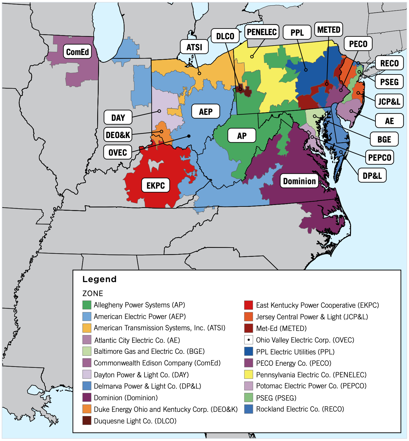
In MATPOWER, there is a bus parameter named “ZONE”, and it means loss zone.
Zone

Region
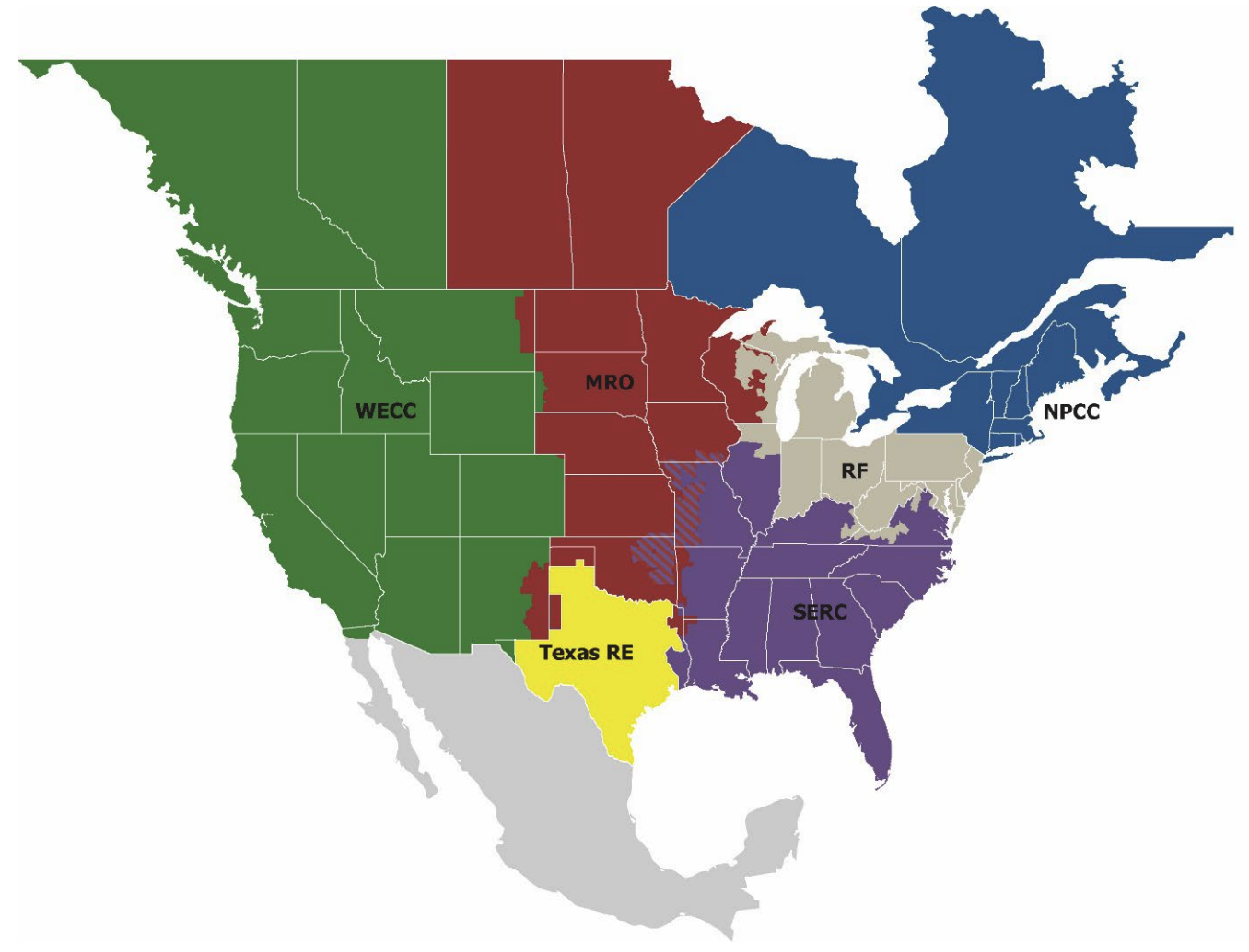
NERC divides North America into several regions for the purpose of reliability and coordination. Each region is responsible for ensuring the reliability of the bulk power system within its boundaries. The six regions are:
- MRO: Midwest Reliability Organization
- NPCC: Northeast Power Coordinating Council
- RF: ReliabilityFirst
- SERC: SERC Reliability Corporation
- Texas RE: Texas Reliability Entity
- WECC: Western Electricity Coordinating Council

eGrid Subregions
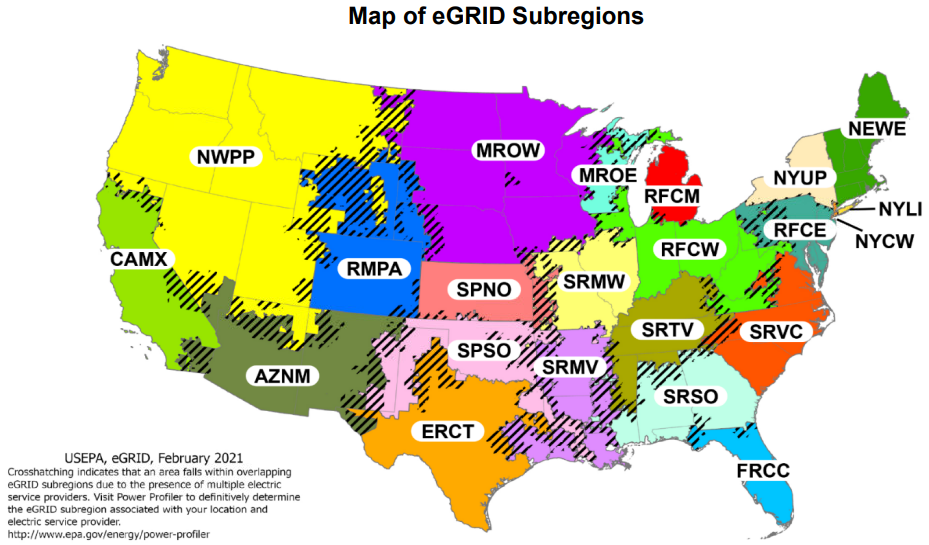
For U.S. grid regions’ emission data, EPA provides recent and historic air emissions, including carbon dioxide (CO2), for U.S. portions of grid regions, States, and Puerto Rico.
EPA’s Emissions & Generation Resource Integrated Database (eGRID) is the preeminent source of air emission data for the U.S. electric power sector. eGRID is based on available data for all U.S. electricity generating plants that provide power to the electric grid and report data to the U.S. government.
eGRID is valuable to users seeking air emission data about the electric power sector in the United States. eGRID is typically used for greenhouse gas registries and inventories, carbon footprints, consumer information disclosure, emission inventories and standards, power market changes, and avoided emission estimate eGRID data are cited by many emission inventory and registry protocols, various emission calculation tools and applications, hundreds of academic papers, and consultants; it is used for many research applications and efforts.
eGRID annually updates its emission data and rates for each of its subregions. It also provides aggregated data by state, U.S. total, and by sets of electric grid boundaries, including NERC regions and eGRID subregions.
